Traffic Impacts
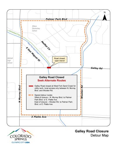
Galley Road between East San Miguel Street and Moffat Circle is temporarily closed. The road closure timeline was extended due to delays in telecommunications relocations in advance of the bridge replacement project. Project completion is expected this summer. Visit the Construction Updates section to learn more about project progress.
As of Jan. 30, 2025, underground telecommunications work is complete. The contractor for the bridge and water pipeline work has started bringing material and equipment to the site. Crews will begin working within the canal in early February. Project completion is expected this summer.
Travelers should plan for additional travel time and seek alternate routes. Two detour routes are signed using North Murray Boulevard and Wooten Road to either Palmer Park Boulevard on the north or East Platte Avenue on the south.
The Homestead Trail is closed between Galley Road and North Murray Boulevard. The trail will remain closed in this area until further notice.
About
The Galley Road bridge over West Fork Sand Creek will be replaced with a new structure that better accommodates high-flow events in the creek, in addition to transportation needs above ground. The new bridge will be approximately 20 feet wider to provide two travel lanes in each direction, a center turn lane, an eight-foot sidewalk on the north side of the bridge, and a 10-foot sidewalk on the south side. A new pedestrian-activated signal will be installed at the Homestead Trail connection at the east end of the bridge.
Project Benefits
- Improves mobility and transportation reliability by reducing the potential for storm water overtopping the canal and closing Galley Road
- Enhances safety by providing wider sidewalks and a signalized trail crossing
- Upgrades a section of Galley Road using current design and safety standards
- Provides more capacity in the canal to accommodate high water events
Construction Updates
This page will be updated frequently during construction with newsletters and updates for the Galley Road Bridge Replacement project.
Text GALLEY to 866-762-3640 to receive text alerts regarding construction updates and traffic impacts.
2025 Updates
2024 Updates
Background
The Galley Road Bridge was built in 1965 and replacement is needed because the bridge is too narrow for the existing 5 lane roadway design and it is also hydraulically inadequate. During drainage high water events the road has overtopped with reports of water flow of 3-4 feet over the road in recent years.
The existing structure is a 5 celled concrete box culvert which offsets and reduces the traffic lane widths and only provides 4’ pedestrian access which does not match the current road design. The newly designed structure does not limit the road design for traffic or pedestrians and would meet drainage requirements with wider and deeper concrete box culverts. Within this project CSU will be upgrading and relocating utilities which will allow water system design advantages to the City of Colorado Springs infrastructure in the Galley Road corridor.


